 Click
into the map to enlarge it
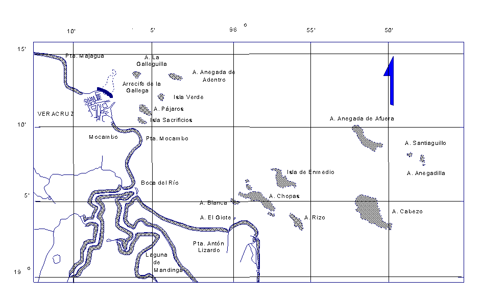
Dangers south of Veracruz
The most southeastern danger is Arrecife Cabezo (19°05'N, 95°50'W),
14 kilometers east of Punta Anton Lizardo. The total area of reef is given
with 18.9 km². The reef is about 3.5 miles long and up to 1.75 miles
wide, and there are two small entrances, one in the west, the other in
the southeast, into the the central lagoon. The lagoon is 29 to 36 meters
depth and near the southern end are two small islets, covered with grass
and composited of fine white sand.
Arrecife Santiaguillo (19°09'N, 95°48'W), about 20 kilometers offshore and Arrecife Anegadilla (19°07'N, 95°48'W) are two small reefs over which the sea breaks heavilyall the time. In to both reefs is no passage and only in the northern part of Anegadilla is a small islet without any vegetation.Santaguillo covers an area of 1.02 km² and Anegadilla of 0.74 km².
Arrecife Anegada de Afuera (19°09'N, 95°51'W), 17 kilometers offshore covers an area of nearly 7.8 km² and is 2.5 miles long and 0.8 miles wide. Near its southern end lies Islote Grande, a small sandy cay with some trees on it. A ruined hut stands near the beach towards the lagoon. A ruined peer, 100 meters long shows inside the lagoon. There is a small passage near the cay.
Arrecife Rizo (19°04'N, 95°55'W), 5.7 kilometers offshore and with an area of 4.4 km² is a small reef over which the sea breaks all the time. There is a small cay which is drying located near the western side of the reef. A small narrow spit, whith a deph of under 2 meters extends about 1.2 miles north of the northern end of the reef.
Isla de Enmedio (19°06'N, 95°56'W) is located 6.8 kilometers offshore and the coplex reef has an area of aboutb6.5 km². Enmedio is about 2 miles long, 1.7 miles wide and the two small sandy cays rising to an elevation of 12 meters on the tops of the trees. There are two small passages into the lagoon, which is deep but frequently dotted witch patches of corall up to 1 feet.
Arrecife Chopas (19°05'N, 95°58'W) is about 3.5 miles long, up to 2.2 miles wide and located 3.4 kilometers offshore. The complete area of reef is given with 8.5 km². There are three small bush covered cays in the southeast of the reef, and a group of other seperated reefs lies south of the cays and west of the northern end of the reef. A ruined irion sructure is reported to stand on the southern most reef. A daylight beacon, 12 meters high is situated on the easternmost islet.
Arrecife Blanca (19°05'N, 96°00'W), 3 kilometers offshore and Arrecife El Giote (19°04'N, 95°59'), 1 kilometer offshore have both an area of only 1 km². Both reefs are drying and a small sandy cay on Blanca is reported to be awash at high tide.
Islote Salmedina (19°05'N, 95°57'W) is a small sandy cay located 0.4 miles offshore Arrecife Blanca, is 5.5 meters high and overbuilt by an iron tower 23 meters high. On the top of the tower stands a leeding light and a racan transmit from a tower 4 meters distant.
Arrecife del Rio (19°06'N, 96°07'N) is a wide drying sand area, located in front of the mouth of Rio del Boca. The island is swampy and covered with mangroves.
 click
into the map to enlarge it
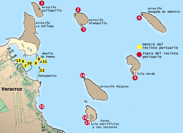
Isla Sacrificios is a small sandy cay with a lighttower on it
Arrecife Pajaros (19°12'N, 96°06'W) about 2 kilometers offshore has an area of nearly 2 km². There are two small sandy cays on the northern end of the reef. Into the central lagoon seams to be no safe entrance.
Isla Verde (19°12'N, 96°04') about 6.3 kilometers offshore is 2.25 square kilometers in area and rising to an elevation of 30 meters on some sandhills. The island stands on the southern end of a drying reef enclosing a lagoon. there is an entrance 1 mile wide on the southside up to 19 ft deep.
Arrecife Anegada de La Adentro (19°14'N, 96°04'W) is located about 9 kilometers offshore and had an area of 2.4 km². It is about 1 mile long and only 0.5 miles wide and is the outernmost danger of reefs in the vicinity to Veracruz habour. A daytime beacon stands on a small sandy cay nera the northeastern end of the reef.
Arrecife La Gallega and Arrecife La Galleguilla (19°14'N, 96°07'W) are two small reefs about 1 kilometer offshore with an area of about 4 km². Arrecife Hornos (19°13'N, 96°08'W) is situated directly in the approach to the habours bay of Veracruz.
Arrecife Blanquilla (19°14'N, 96°07'W), about 0.5 miles
in extent lies 1.7 miles west of Arrecife Anegada de la Adrentro. The reef
has an area of about 1.3 km² and is located 3.5 kilometers offshore.
There is a small sandy cay on it.